The Best Hiking Trails in Cafayate for Your Next Trip
Cafayate is a desert gem in Northern Argentina. Most visitors come for the famous Torrontés wine. However, the surrounding red mountains offer incredible scenery for hikers. You will find massive canyons and hidden waterfalls here. Finding the best hiking trails in Cafayate requires some local knowledge. The terrain is often dry and rugged. Some paths lead through ancient archeological sites. Others take you deep into the heart of the Quebrada de las Conchas. This guide covers everything you need for a safe trek in 2026. Get ready to explore one of the most unique landscapes in the world.
Top 10 Trails for Every Level
Cafayate offers a mix of easy strolls and challenging climbs. Most trails are located within a short drive from the town center. You can see world-class geological formations on almost every route. Here are our top picks for the top attractions near Cafayate for hikers.
- Quick Pick: Best for Waterfalls: Cascadas del Río Colorado.
- Quick Pick: Best for Views: Los Estratos.
- Quick Pick: Best for Families: El Anfiteatro.
- Quick Pick: Best for Sunsets: Cerro de la Cruz.
-
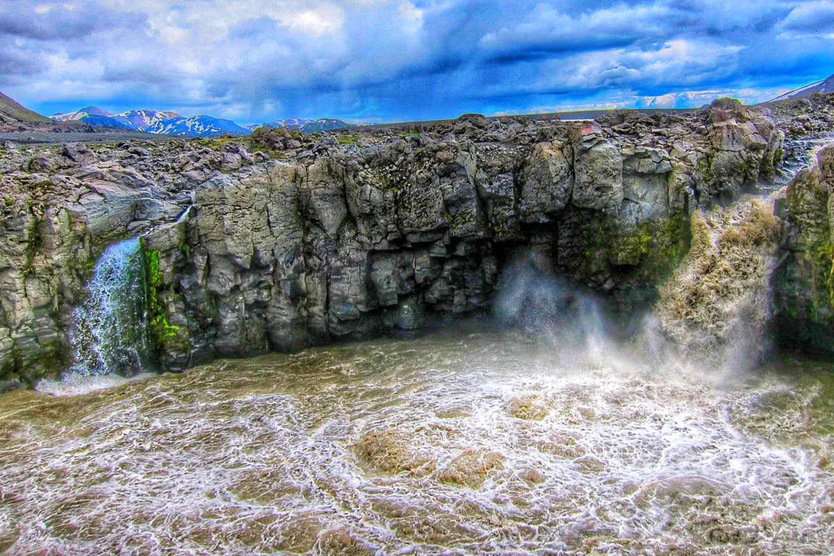
Name: Cascadas del Río Colorado
Type: Waterfall trek
Why go: This is a classic adventure through seven different waterfalls. The trail stays cool even in the heat because of the river.
Best for: Adventure seekers and families.
Where: El Divisadero area, south of town.
Time: 3-4 hours.
Cost: Small entry fee to the local community; guide recommended.
Getting there: 15-minute taxi from the main plaza.
Tip: Wear shoes that can get wet as you will cross the water often. Check out the full Rio Colorado waterfall hike guide before you go. -
Name: Los Colorados
Type: Desert canyon hike
Why go: This trail sits right behind the town. It offers deep red rock walls and sandy paths.
Best for: A quick morning workout.
Where: Entrance near the town outskirts.
Time: 1.5-2 hours.
Cost: Usually free.
Getting there: Walkable from most hotels.
Tip: Go early to catch the soft morning light on the red rocks. -
Name: La Yesera & Los Estratos
Type: Geological sightseeing
Why go: It features multi-colored layers of rock called the "Earth's Rainbow." The views are some of the most famous in the region.
Best for: Photographers.
Where: Quebrada de las Conchas.
Time: 1.5 hours.
Cost: Free access from the road.
Getting there: 25-minute drive via Route 68.
Tip: Look for the "Los Estratos" sign to find the start of the footpath. -
Name: Garganta del Diablo
Type: Short canyon scramble
Why go: You hike into a massive, circular red rock throat. It feels like standing inside a giant chimney.
Best for: Those who like light rock scrambling.
Where: Route 68.
Time: 45 minutes to 1 hour.
Cost: Free entry.
Getting there: Part of a Quebrada de las Conchas tour.
Tip: The climb to the very back requires using your hands for balance. -
Name: El Anfiteatro
Type: Sightseeing walk
Why go: This natural stone amphitheater has incredible acoustics. It is a short walk from the parking area into the heart of the rock.
Best for: Every visitor.
Where: Route 68.
Time: 30 minutes.
Cost: Free entry; small tip for local musicians is common.
Getting there: Located right next to the Garganta del Diablo.
Tip: Wait for the local folk singers to perform to hear the echo. -
Name: Cerro de la Cruz
Type: Hilltop viewpoint
Why go: This is the highest point near town. It provides a panoramic view of the entire Calchaquí Valley and the vineyards.
Best for: Sunset views.
Where: Near the western edge of town.
Time: 1 hour round trip.
Cost: Free.
Getting there: Walk from the town center.
Tip: The path is dusty, so bring plenty of water even for this short hike. -
Name: El Divisadero Archeological Site
Type: Historical nature trail
Why go: See ancient ruins and cave paintings from the Diaguita culture. It mixes history with beautiful desert scenery.
Best for: History buffs.
Where: Southeast of Cafayate.
Time: 2 hours.
Cost: Small community entrance fee.
Getting there: taxi or drive toward the mountains.
Tip: Hire a local guide at the gate to explain the rock art. -
Name: Los Castillos
Type: Sightseeing trail
Why go: Massive rock formations that look like medieval castles. The trail winds around the base of these towers.
Best for: Casual walkers and families.
Where: Route 68 entrance to the Quebrada.
Time: 1 hour.
Cost: Free.
Getting there: First major stop when coming from Salta.
Tip: Visit during the "golden hour" before sunset for magical photos. -
Name: Quebrada de las Flechas
Type: Day trip desert hike
Why go: This area features jagged gray rock formations pointing to the sky. It looks like a different planet.
Best for: Unusual landscape lovers.
Where: Route 40 towards Molinos.
Time: 2-3 hours (excluding drive time).
Cost: Free.
Getting there: Car rental or tour required. You can read more in our Quebrada de las Flechas guide.
Tip: The drive is on a gravel road, so check your tires. -
Name: San Lucas to San Carlos
Type: Rural mountain trek
Why go: This takes you through remote villages and mountain valleys. It is much more green than the red canyon areas.
Best for: Experienced hikers seeking solitude.
Where: Near the village of San Carlos.
Time: 6-8 hours.
Cost: Free, but local logistics may cost.
Getting there: Bus or car to San Carlos.
Tip: This is one of the intermediate level hiking trails near Cafayate and requires a full day.
Planning for Best Hiking Trails in Cafayate
Hiking in a desert requires specific preparation. The sun in Northern Argentina is very strong. Temperatures can reach 35°C in the summer. Winters are mild but can be cold at night. For 2026, always check current path conditions at the local tourism office. You can find their official info on the Turismo Salta website.
Hydration is your biggest priority on these trails. Bring at least two liters of water for any hike over two hours. There are very few natural springs in the red canyons. Sunscreen and a wide-brimmed hat are mandatory. We have a detailed list of what to pack for hiking in the Cafayate desert to help you prepare.
You should also consider your transport options. Many trailheads are on Route 68. If you do not have a car, consider renting bicycles in Cafayate for closer trails. Taxis are also a reliable way to reach the Rio Colorado area. Always arrange a pickup time with your driver before heading out. Signal can be weak in the canyons.
Nearby Adventures Worth the Drive
If you have extra time, explore beyond the town. The Calchaquí Valley is full of hidden paths. Many lead to high-altitude viewpoints. Others follow ancient trade routes. The background history of this region is rich with stories of the Inca and local tribes. Their influence is visible in many mountain paths.
For a different vibe, visit the nearby town of San Carlos. It is one of the oldest settlements in the region. There are several trails that start from the riverbeds there. This area is less crowded than the main Quebrada attractions. It offers a peaceful way to see the local flora and fauna.
Finally, remember that the high altitude affects your breathing. Cafayate sits at 1,683 meters above sea level. Some trails go much higher. Take your time on steep climbs. Listen to your body and rest when needed. The views from the top will always be worth the effort.
Frequently Asked Questions
When is the best time to hike in Cafayate?
The best time is from April to October. During these months, the weather is dry and clear. Summer months (January to March) can be very hot. Heavy rain in summer may also flood river-based trails like Rio Colorado.
Do I need a professional guide for hiking in Cafayate?
For trails like Los Colorados or Route 68 stops, you do not need a guide. However, for the Cascadas del Río Colorado, a guide is highly recommended. The paths can be confusing and slippery. Local guides provide safety and historical context.
Is hiking safe in the Salta region?
Yes, hiking is generally safe. The main risks are sun exposure and dehydration. Always tell someone your planned route. Stick to marked trails and bring a physical map or offline GPS. Most people in Cafayate are very helpful to tourists.
Finding the best hiking trails in Cafayate allows you to see the real heart of Argentina. Beyond the vineyards lies a world of red rock wonders. Whether you want a short walk at El Anfiteatro or a long trek to San Lucas, there is something for you. Remember to pack plenty of water and respect the desert environment. For more ideas on how to spend your time, look at these top attractions near Cafayate. Enjoy your 2026 mountain adventure!
Official resources
Use these sources for official schedules, tickets, routes, and updates.
- Turismo Salta — Official provincial tourism board; unverified.
- Visit Argentina — Official national tourism board; unverified.
- UNESCO World Heritage Centre — Official UNESCO listing for regional heritage; unverified.
- Lonely Planet — Major international travel guide; unverified.
- Museo de la Vid y el Vino — Official museum of the city; unverified.
- Aeropuertos Argentina 2000 — Official airport authority for the region; unverified.