Ultimate Packing list for hiking in the Córdoba mountains Argentina
Trekking through the Sierras de Córdoba is a highlight for many visitors to Argentina. These ancient peaks offer rugged granite paths and stunning high-altitude views. To enjoy these routes safely, you need a precise packing list for hiking in the Córdoba mountains Argentina. The weather here shifts rapidly from hot sun to freezing winds. Many of the best hiking trails near Córdoba require sturdy equipment to handle the rocky terrain. Being prepared means you can focus on the breathtaking scenery. This guide ensures you have everything needed for a successful 2026 adventure.
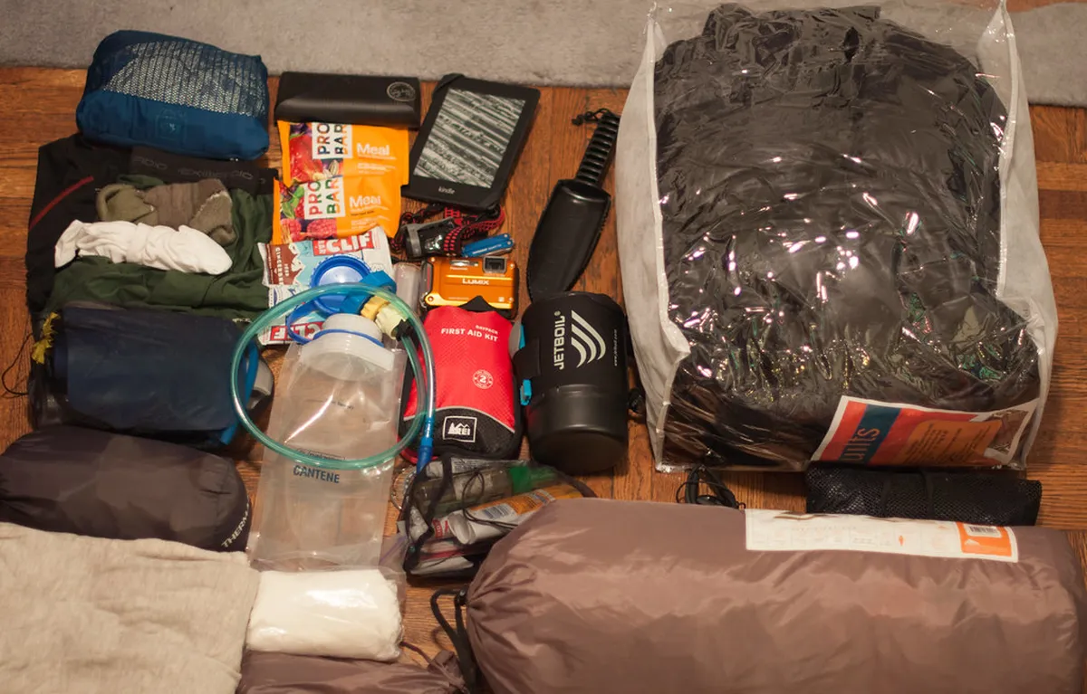
Essential Packing list for hiking in the Córdoba mountains Argentina
Preparation is the key to safety in the central Argentine highlands. The sun in the Pampa de Achala is intense even on cool days. You should prioritize moisture-wicking clothes to manage sweat and temperature changes. Avoid cotton, as it stays wet and gets cold quickly. A lightweight windbreaker is essential for the gusty summits common in this province.
For footwear, choose boots with excellent ankle support. The trails often consist of loose stones and slippery granite. If you plan a multi-day trek, high-quality trekking poles will save your knees. Always check the latest park requirements on the Agencia Córdoba Turismo website before heading out. Proper gear makes these remote locations much more accessible and enjoyable.
- Layered Clothing: Synthetic base layer, fleece mid-layer, and waterproof outer shell.
- Sun Protection: High SPF sunscreen (50+), polarized sunglasses, and a wide-brimmed hat.
- Hydration: At least 2 liters of water per person for day hikes.
- Navigation: Downloaded offline maps or a physical topographic map.
- First Aid: Blister kits, bandages, and personal medications.
10 Top Trails to Test Your Packing Gear Near Córdoba
Using the right gear allows you to explore the top attractions near Córdoba with confidence. Each location has unique challenges, from deep canyons to high ridges. Whether you seek easy walks or intense climbs, the gear remains largely consistent. Here are the best spots to put your equipment to use.
-
Name: Cerro Champaquí
Type: Experience
Why go: It is the highest peak in the province at 2,790 meters.
Best for: Experienced trekkers
Where: Calamuchita Valley
Time: 2-3 days
Cost: Guide fees vary
Getting there: Drive to Villa Alpina to start the classic ascent.
Tip: Hire a local guide for safety and better logistics. -
Name: Los Gigantes
Type: Nature
Why go: This granite massif offers spectacular rock climbing and winding trails.
Best for: Rock enthusiasts
Where: Tanti region
Time: 6-8 hours
Cost: Small entry fee for private lands
Getting there: Take a bus or drive from Villa Carlos Paz day trip routes.
Tip: The trail can be confusing, so follow yellow paint markings. -
Name: Quebrada del Condorito
Type: National Park
Why go: It is the best place to spot massive Andean condors in flight.
Best for: Bird watchers
Where: Pampa de Achala
Time: 4-5 hours
Cost: Free (check official site for 2026 updates)
Getting there: Bus from Córdoba city toward Altas Cumbres.
Tip: Bring a windproof jacket as the plateau is very exposed. -
Name: Cerro Uritorco
Type: Experience
Why go: Known for its mystical legends and incredible sunset views over Silla valley.
Best for: Spiritual seekers
Where: Capilla del Monte
Time: 7 hours
Cost: Moderate entry fee
Getting there: Drive 100km north of Córdoba via Route 38.
Tip: Start before 9 AM to avoid being turned back for time. -
Name: La Cumbrecita Alpine Trails
Type: Neighborhood
Why go: This pedestrian-only village offers several charming forest trails nearby.
Best for: Families
Where: Calamuchita Valley
Time: 2-3 hours
Cost: Free (parking is paid)
Getting there: Drive through the scenic roads from Villa General Belgrano.
Tip: Visit the Cascadas Grande for a refreshing break. -
Name: Cerro Pan de Azúcar
Type: Viewpoint
Why go: Offers 360-degree views of the city and the vast Punilla Valley.
Best for: Quick views
Where: Cosquín
Time: 2 hours
Cost: Free
Getting there: Drive the gravel road from Villa Allende or Cosquín.
Tip: There is a chairlift option if you want to skip the climb. -
Name: Los Terrones
Type: Nature
Why go: It features bizarre red sandstone formations and deep narrow canyons.
Best for: Photography
Where: Near Capilla del Monte
Time: 3 hours
Cost: Entry fee includes a guide
Getting there: Short drive from Route 38 north of the city.
Tip: Wear shoes with good grip for the sandy stairs. -
Name: Ongamira Valley
Type: Experience
Why go: Features ancient caves and stunning reddish hills full of history.
Best for: History buffs
Where: North of Punilla
Time: 4 hours
Cost: Low entry fee
Getting there: Private transport is highly recommended for this remote area.
Tip: Visit the Colchiqui hill for the best panoramic photos. -
Name: Mogote Carlos Paz
Type: Activity
Why go: A classic steep hike with a view of the San Roque Lake.
Best for: Active locals
Where: Villa Carlos Paz
Time: 3 hours
Cost: Free
Getting there: Accessible from the city center of Carlos Paz.
Tip: Pack extra water as the trail is very sunny. -
Name: El Zapato
Type: Nature
Why go: A natural rock formation shaped like a giant shoe overlooking a lake.
Best for: Casual walkers
Where: Capilla del Monte
Time: 1 hour
Cost: Low fee
Getting there: Walkable from the town center of Capilla del Monte.
Tip: Go at sunset for the most dramatic lighting.
Regional Hiking Tips for Your 2026 Adventure
When wandering these hills, remember that many areas are private property. Respect local gates and closures to maintain access for everyone. If seeking more relaxed terrain, look into the easiest hiking trails near Córdoba city for a gentle start. Always inform someone of your route before departing for the day.
The weather in 2026 remains as unpredictable as ever. Summer brings sudden thunderstorms while winter can see surprise snow on high peaks. It is wise to cross-reference weather reports with the Visit Argentina national portal. Carry a power bank for your phone to ensure navigation tools remain functional. These small steps ensure your mountain trip stays safe and memorable.
Frequently Asked Questions
What is the best time of year to hike in Córdoba?
March to May and September to November are ideal. These months offer mild temperatures and less rainfall. Summer can be too hot, while winter brings freezing night temperatures to the higher summits. Always check local forecasts before heading into the mountains.
Do I need a guide for hiking in Córdoba?
For major peaks like Champaquí, a guide is highly recommended. Many trails are poorly marked and cross private land. For shorter trails near towns like Villa Carlos Paz, experienced hikers can often navigate alone using reliable offline maps.
Are there dangerous animals in the Córdoba mountains?
The main concerns are snakes and scorpions, though encounters are rare. Wear high boots and long trousers for protection in tall grass. Andean condors and pumas live in the area, but pumas are very elusive and usually avoid humans.
Having a solid packing list for hiking in the Córdoba mountains Argentina ensures a fantastic journey. From the towering heights of Champaquí to the condor sightings at Quebrada del Condorito, preparation is vital. Use this gear guide to stay comfortable regardless of the weather. For more trip planning help, explore the top attractions near Córdoba today. Pack your bags and enjoy the unique beauty of central Argentina!
Official resources
Use these sources for official schedules, tickets, routes, and updates.
- Municipalidad de Córdoba — unverified: Official government portal for the city.
- Agencia Córdoba Turismo — unverified: Provincial tourism board for Córdoba province.
- UNESCO World Heritage Centre — unverified: Official UNESCO listing for the Jesuit Block.
- Lonely Planet — unverified: High-authority editorial travel guide.
- Universidad Nacional de Córdoba — unverified: Major public educational and historical institution.
- Aeropuertos Argentina 2000 — unverified: Official airport management authority.