10 Best Taquile Island Paths for Local Culture in 2026
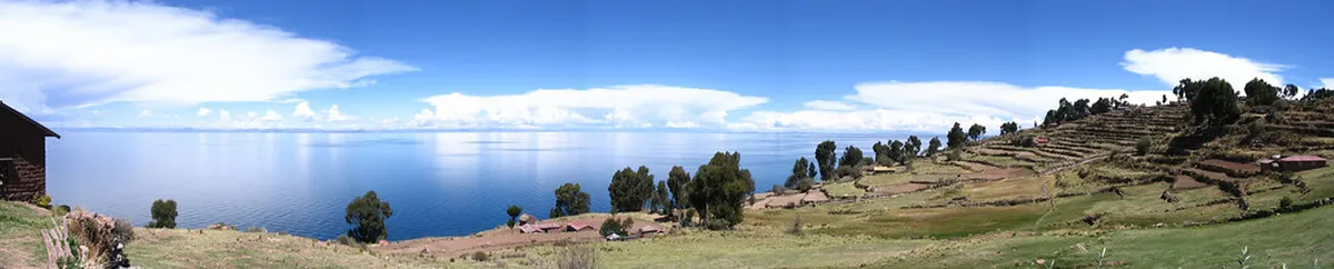
Taquile Island sits high in the waters of Lake Titicaca. It is famous for its unique social structure and master weavers. To see the real island, you must leave the boats behind and walk. The Best Taquile Island paths for local culture lead you through stone arches and terraced fields. These ancient trails offer more than just views of the blue water.
Walking here is a slow and steady process. The altitude makes every step feel significant. You will pass men knitting while they walk and women in colorful skirts. Most visitors start their journey from Puno by ferry. This guide helps you choose the best routes for a memorable cultural experience.
- Best Overall: Plaza de Armas Central Path
- Best Views: Mulsina Hill Peak Trail
- Best for Families: Playa Collata Shoreline
- Best for Tradition: Communal Textile House Path
10 Best Taquile Island Paths for Local Culture
Discovering Taquile requires a love for walking and an open mind. The island has no cars or motorcycles. This keeps the air fresh and the paths quiet. Most hikers will find the routes follow traditional stone-paved paths. These were built centuries ago and are still used today.
As you explore, you will notice the island is divided into sectors. Each path provides a glance into the daily lives of the residents. Many of these routes connect to other top attractions near Puno within the lake region. Please stay on the marked trails to respect the local farms.
-
Name: Main Harbor Staircase (El Arco entry)
Type: sight|activity
Why go: This is the iconic entrance to the island. You walk up over 500 stone steps. It offers a grand introduction to the island's scale.
Best for: Fit hikers and photographers.
Where: Port of Salancancha.
Time: 45 minutes.
Cost: Included in island entry fee.
Tip: Take many breaks to breathe due to the high altitude. -
Name: Plaza de Armas Central Path
Type: culture|sight
Why go: This is the heart of the community. You can see the town hall and local church. It is the best place to observe the local clothing hierarchy.
Best for: Cultural enthusiasts.
Where: Center of the island.
Time: 20 minutes.
Cost: Free access.
Tip: Visit at noon to see locals gathering for lunch. -
Name: South Coast Traverse
Type: experience|nature
Why go: This path is quieter than the main port route. It winds past sheep pastures and pre-Inca terraces. You get a deep sense of the island's isolation.
Best for: Solitude seekers.
Where: Southern ridge.
Time: 1.5 hours.
Cost: Free.
Tip: Wear a hat as there is very little shade here. -
Name: Mulsina Hill Peak Trail
Type: viewpoint|activity
Why go: It is the highest point on the island. You can see across the lake to the snowy peaks of Bolivia. It is a powerful spot for sunset or sunrise.
Best for: Stunning panoramas.
Where: Western high point.
Time: 1 hour.
Cost: Free.
Tip: Only attempt this if you are well-acclimatized to the altitude. -
Name: Communal Textile House Path
Type: experience|culture
Why go: Taquile’s textile art is protected by UNESCO. This path takes you straight to the weaving center. You can see high-quality belts and hats.
Best for: Souvenir hunters and art lovers.
Where: Just off the main plaza.
Time: 30 minutes.
Cost: Free to enter (merchandise costs extra).
Tip: Ask for the meaning behind the symbols on the belts. -
Name: Northern Stone Gate
Type: sight
Why go: These gates mark the boundaries between different island communities. Walking through them is a symbolic experience. The masonry is precise and beautiful.
Best for: History buffs.
Where: North entrance trail.
Time: 15 minutes.
Cost: Free.
Tip: This is the best spot for a photo of the lake framed by stone. -
Name: Playa Collata Shoreline Path
Type: nature|experience
Why go: Most paths are high up, but this leads to the water. In summer, you might see locals near the shore. It is a much flatter walk than the staircases.
Best for: A relaxed afternoon.
Where: Eastern shore.
Time: 40 minutes.
Cost: Free.
Tip: The water is very cold, so dipping your feet is usually enough! -
Name: Agricultural Terrace Loop
Type: experience|nature
Why go: Taquile is famous for vertical farming. This path weaves through active potato and quinoa fields. It shows how the locals sustain themselves.
Best for: Understanding local life.
Where: Northeast slopes.
Time: 1 hour.
Cost: Free.
Tip: Do not step on the crops while taking photos. -
Name: Port of Chilcano Descent
Type: activity|sight
Why go: This is an alternative way to leave the island. It is less crowded than the main port. The views of the reed beds are excellent.
Best for: Avoiding the main tourist crowds.
Where: West coast.
Time: 30 minutes.
Cost: Free.
Tip: Ensure your boat captain knows to pick you up here. -
Name: Santiago de Taquile Viewpoint
Type: viewpoint|culture
Why go: This trail passes several small family shrines. It provides a spiritual perspective on the island. The walk is peaceful and mostly paved with stone.
Best for: Quiet reflection.
Where: Near the secondary school.
Time: 45 minutes.
Cost: Free.
Tip: Always greet locals with a friendly "Aski-puro" (Good day).
Hiking Taquile Island: Terrain and Difficulty
The trails on Taquile are not technically difficult. However, the altitude is nearly 4,000 meters above sea level. This makes any physical exertion feel twice as hard. Most paths are made of cobblestone or packed earth.
Before you go, it is helpful to understand how difficult is the taquile island hike for your fitness level. The main staircase is the biggest challenge for most. It involves steady climbing on uneven steps.
If you have knee issues, consider using the alternative sloping paths. These take longer but are much easier on the joints. Always wear sturdy shoes with good grip. The stones can become slippery after a light rain.
How to Plan Your Taquile Island Hike from Puno
Reaching these paths starts with a boat ride from Puno. Most Lake Titicaca boat tours include a stop at Taquile. These boats usually depart early in the morning. The journey takes about two to three hours each way.
Check the Peru Travel official site for updated ferry schedules. You will likely pay a small entry fee to the local community upon arrival. This money helps maintain the ancient paths you will walk on.
You can also find information about other routes in the Taquile Island hiking trails overview. Remember that the island runs on its own time. Do not rush your hike. Allow yourself at least four hours on the island to see the main sights.
Frequently Asked Questions
What is the best time to visit Taquile Island for hiking?
The best time to visit is during the dry season from May to September. Days are sunny and clear, offering the best views of the Andes. However, nights can be very cold. Early morning departures from Puno ensure you have enough daylight for the long walks.
Are the hiking trails on Taquile Island safe for solo travelers?
Yes, the island is very safe and has almost zero crime. The community is tight-knit and welcoming. Solo travelers should stay on marked paths and watch their step on the steep stone stairs. Always carry enough water and sun protection.
What should I wear for a cultural hike on Taquile?
Layered clothing is essential because the temperature changes quickly. Wear a sun hat and high-SPF sunscreen. Decent walking shoes or hiking boots are recommended for the stone steps. Avoid revealing clothing to stay respectful of the traditional local culture.
Taquile Island offers a rare look at a living culture. By exploring the Best Taquile Island paths for local culture, you connect with history and tradition. The combination of intense blue water and vibrant textiles is unforgettable. Whether you climb the main stairs or wander the southern ridge, take your time. If you want to see more of the region, consider visiting the Sillustani burial towers guide for your next day trip.
Official resources
Use these sources for official schedules, tickets, routes, and updates.
- Peru Travel — unverified: National tourism board of Peru.
- Municipalidad de Puno — unverified: Official city government website.
- Gobierno Regional de Puno — unverified: Regional government authority for Puno.
- UNESCO World Heritage Centre — unverified: International heritage authority for Qhapaq Ñan.
- Lonely Planet — unverified: Leading international travel guide.
- Aeropuertos Andinos del Perú — unverified: Operator of the Juliaca airport serving Puno.